How can bicyclists and pedestrians get to Herrontown Woods and Smoyer Park from nearby neighborhoods? Snowden Lane has long been a narrow road with steep ditches on either side,
creating a hazard even for cars. In recent years, houses have popped up along this stretch, transforming a charming country road into a suburban street. It's time to add sidewalks so that Herrontown Woods and Smoyer Park are no longer isolated from the neighborhoods they are supposed to serve.
Yet we're told that any bikeway would be too expensive, given the presence of wetlands, specifically where Snowden crosses a tributary of Harry's Brook.
Here is a status report, and a potential low-cost solution.
First, some good news: There's now a bikeway along the edge of Windy Top. But to make this stretch of bikeway useful, additions need to be made at either end.
At the north end, at the top of the hill, the Windy Top bikeway deadends, 250 feet short of the entrances to Herrontown Woods and Smoyer Park. Can the town fill in this gap?
Meanwhile, at the downhill, southern end of the Windy Top portion of bikeway, the Prentice development is going in, and has already laid the gravel bed for a bikeway that will extend down to Van Dyke Road. This is great news. If the town can complete that pesky 250 feet mentioned above, we will soon have a bikeway accessible to anyone approaching from Van Dyke.
But how to extend the bikeway down Snowden Lane along what is called "the gauntlet" that separates the parks from the Littlebrook neighborhood?
There is a ditch on the west side of the road where the trail needs to go. The ditch runs downhill a couple hundred feet, then heads under the road to open space land on the other side.
Might the town be able to divert this water under the road right at the intersection with Van Dyke, so that runoff can spill into the open space wetland rather than run down this ditch?
(the ditch begins at the right of this photo)
The ditch would then be filled, and a bike/ped path be built on top. Town officials say that the state views the ditch as "wetland," and so would resist filling it in. Since the whole purpose of a ditch is to carry water away, thereby lowering the water table and drying out surrounding land, it's hard to understand how a ditch can be valued by the state as wetland, particularly if water can instead be diverted to the other side of the road to feed wetlands on that side.
Building a bike/ped path adjacent to the road, where the ditch is currently, would use the Windy Top approach (in the photo) just up the street, and extend the bikeway down along the currently dangerous stretch we call the "gauntlet."
With a paved bikeway on the right (west) side, that could extend the bikeway most of the way to Overbrook Drive.
But before the bikeway can get safely to the sidewalk that starts at Overbrook Drive, it first must get across a stream, and a paved bikeway might not be allowed in the floodplain of a stream.
One approach might be to make this portion, going down to the stream and up the other side, more of an unpaved pathway. Permission would be needed from the homeowners on either side of the stream.
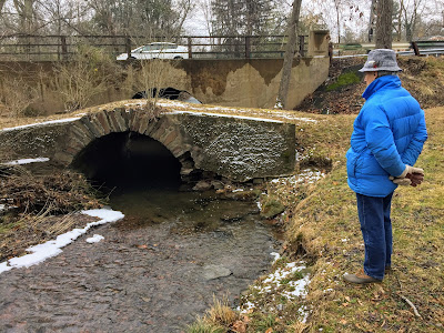
And for getting over the stream, there's a lovely
old stone bridge that few have noticed, but which is worth preserving.
This old bridge is right next to the newer one used by cars on Snowden Lane. Extend the pathway up the other side and you can connect with an existing bikeway that heads to Littlebrook Elementary school and downtown Princeton.
A dialogue with town staff would be needed in order to see if this approach could possibly be used.